RC100 Downhill Blast
Course Developer: Jenny McLaughlin
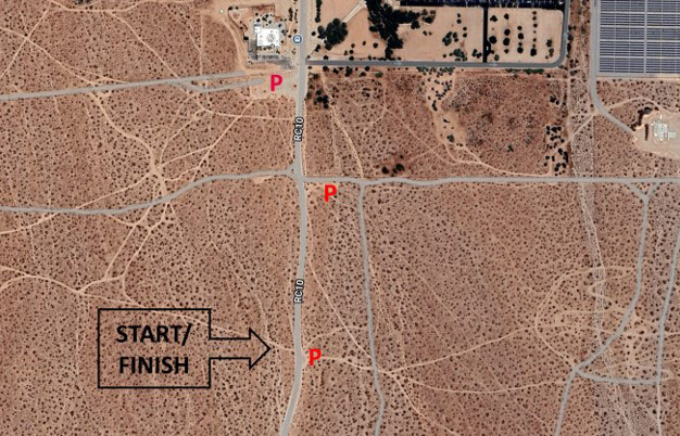
This course starts in the little parking lot on the east side of College Heights Blvd about one-quarter miles south of our familiar dirt parking lot south of Cerro Coso. If that little lot is full, there are a few other spots to park within a short walking distance.
The green buttons will take you to a Course page on Garmin Connect, or a Route on Strava. If you need a .gpx file, you will be able to download that from either of these route pages. You can review the route navigation instructions here.
Course Description
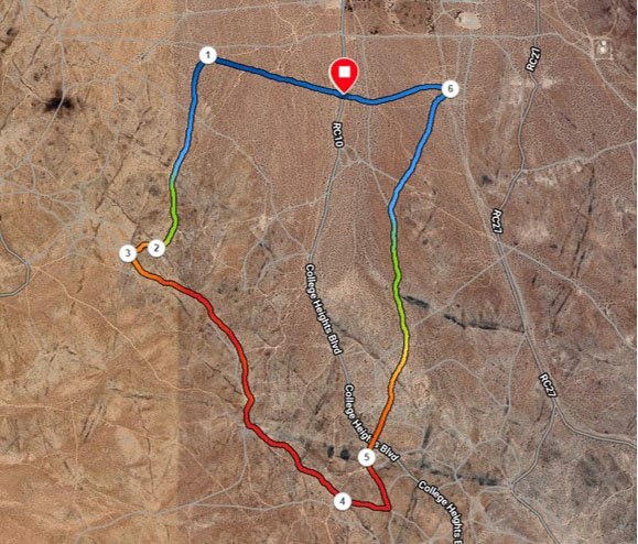
- Standing in the little parking lot, looking west across College Heights Blvd, locate the motorcycle trail. Start by running west onto that trail, and continue west. You will pass points where R/C 78 merges onto the trail from your right and where it veers off on your left. But, keep going west.
- About .4 miles in, turn left onto a Jeep road that heads up slope southward. This road is fairly sandy, full of loose dirt and gravel. It will cross R/C 4 and eventually enter a drainage on the slopes of the ridge to the west. Ignore the bicycle and motorcycle trails that cross your road.
- At the major Y a little past 0.9 miles from the course start, go to the right up the steep climb to the ridge top.
- About 1 mile from the start, just short of the very top of the ridge, turn left onto a road heading to the southeast.
- Follow the ridge for about 1 mile. There will be a few forks in the road. In most cases, you will veer to the left and stay on the eastern side of the ridge.
- At about 2 miles from the start (waypoint 4), head down an unnumbered road. It will at first be a gentle descent, and then steepen at a sharp corner where it merges with RC12 near a large painted boulder on your right. In a few yards you can look to your left to see a very large boulder with two shiny commemorative plaques.
- Soon you pass a heavily used flat parking/camping/partying area on your left, along R/C 100. at the north end of this area, about two and one-quarter miles from the start, merge onto R/C 100. Keep to the right, where the brown paddle shows R/C 100. You will cross College Heights Blvd. (R/C 10), and continue on R/C 100 as it goes first up a little bit, and then nicely downhill for almost one mile.
- Eventually, your route enters a motocross practice track. Stay on R/C 100 as it crosses motorcycle tracks, dips down into a wide arroyo draining from the south, then back up the other side of the arroyo.
- At the top of the arroyo, make a sharp left turn onto a motorcycle trail that heads west across the motocross practice track and beyond. Keep heading west-ish until you reach the start/finish point at the little parking lot.
Waypoint Legend
| Waypoint | Description | Distance from Start, miles | Distance from Previous Waypoint, miles |
|---|---|---|---|
| 1 | Turn south upslope on Jeep road | 0.37 | 0.37 |
| 2 | Major Y where trail heads upslope to right. | 0.92 | 0.55 |
| 3 | Take first trail to left near ridgetop. | 1.01 | 0.09 |
| 4 | Turn left off ridge | 1.96 | 0.95 |
| 5 | Merge onto RC 100 | 2.23 | 0.27 |
| 6 | Sharp left onto trail in middle of motorcycle practice track. | 3.28 | 1.05 |