Gateway Fun
Course Developer: Jessica Kormelink
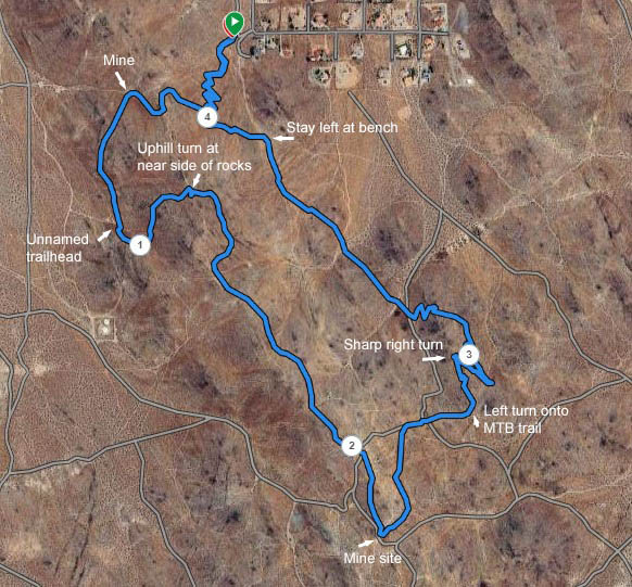
This is a loop course, on the trails around the ridge east of the college. It is run counter-clockwise. Distance is about 4.3 miles, with a total elevation gain of about 970 ft.
Park at the Gateway Trailhead, at the southwest corner of the Belle Vista development. To get there on pavement, head toward the college on College Heights Blvd. and turn left on Kendall. Follow Kendall east, across Gateway, to the end of the pavement at Richmond Road. Turn right and go south on Richmond until it ends at Belle Vista. Turn right on Belle Vista to reach the trailhead.

The route starts at the west entry from the parking lot. Head south, then southwest at the south end of the parking area, then back south, to the bike-hike switchbacks. At .32 miles you will reach a junction with a trail contouring from the ridgetop. Stay left here, then look for a less prominent trail coming from the right just a bit further on, at .34 miles. Turn right on this trail, heading to the ridgetop.
At .46 miles veer left toward the ridgeline, then another left near a plaque to merge with the main trail along the ridgeline, heading south. Go a little ways south, then turn right at .5 miles to take the trail down to the old mine covered with a grate. Just as you come into the mine site, veer left to take the jig down to the trail traversing the hill going south. Stay on this trail until you reach the parking/picnic area at .92 miles. Cross the parking area and continue on the trail heading back up onto the hillside. After crossing the wash, stay on this trail, heading back north, until you almost reach the ridgeline again. Just before reaching a large rock outcropping near the ridgeline, turn up the rocky trail on the near side of those large rocks. Scramble up for a short distance and intersect a trail contouring from the south. Turn left, go across the ridgeline here, and continue on around to the northeast side of the hill. The trail will loop back around to the ridgeline at about 1.46 miles, after passing some old mine tailings. (You do not go to the top).
Continue along the ridgeline to about 1.56 miles and veer left onto the MTB trail that traverses the hill, below the next peak. (This will be the second of two trails that branch from the main trail at that saddle.) At 1.83 miles, before reaching the old mine, veer right to go up to the ridgeline again.
Once on ridgeline (1.87), continue south, taking the less rocky and steep trail up along the east side of the next ridgeline hill, and merge back onto the ridgeline. Keep heading along ridgeline and down the hill until, at about 2 miles, you meet up with the MTB trail that traverses over to the old mine site with the concrete slab. Go left around the concrete slab and look for a singletrack trail (2.24 miles) contouring around the hill and heading to the northeast. Do not go up the loose steep dirt road.
Stay on this trail until you merge with a dirt road (2.38 miles), then follow that dirt road, crossing a couple of roads coming off the top of the ridge, until you intersect a dirt road at 2.5 miles. Turn right on the intersected road and continue down this dirt road until you reach 2.68 miles and the road would drop over the hill. Turn left onto another MTB trail here. (There are a couple of faint MTB trails branching to the left in the dip before this. Look for this trail leaving the road after you start to ascend.)
Continue on this MTB trail around the rock outcropping and down the ridge (has zigzags on it, stay on them). At 2.8 miles, as you go over some down-sloping rocks and continue down, prepare for a sharp right turn. Make sure you take the left jig that eases you into a nearly 180-degree right turn to take you back to the southeast. DO NOT take the trail that continues straight down the ridgeline.
As you traverse the trail, you will pass the first burned turn (switchback) for bikes (2.89), continue across the dirt road that goes straight down the hill, and turn at the switchback just past the road. Don't cut this corner! Continue on down the bike trail, there shouldn't be any other possible turnoffs until you get to the bottom, several switchbacks down for a nice descent to a sandy dirt road.
At that road (3.31 miles), turn a bit to the northwest to run across and down just a bit to continue on trail. This trail will take you pretty much straight northwest. Along the way, it will follow a dirt road for a short time, then leave it, and cross a couple of dirt roads in a wash. After crossing the wash and ascending a rise, it merges (3.72) with a northbound trail heading for the trailhead.
When you reach the main northbound trail (3.72 miles), turn right for the last leg back to the car. At a bench (3.86), veer left and stay on the trail -- do not go down the dirt roads.
Continue down the trail back to the start point, tuning onto the switchbacks that you came up earlier. Please stay on the main trail doing all switchbacks and don't take any of the short cuts that go straight down the hill.
And you made it! Hope you enjoyed it.
The green buttons will take you to a Course page on Garmin Connect, or a Route on Strava or MapMyRun. If you need a .gpx file, you will be able to download that from any of these route pages. You can review the route navigation instructions here.