Rademacher Rim Run
Course Developer: Wesley Elmore
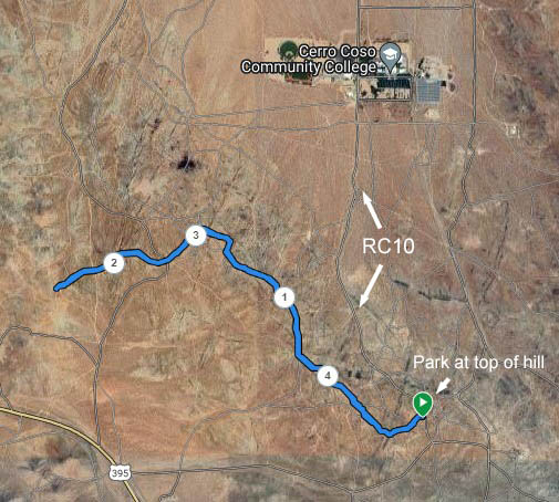
The start and finish of this course is at the top of the dirt College Heights road, BLM RC10. Drive past Cerro Coso College until the top of the hill. Parking is available on both sides of the road there.

This is an out and back course, about 4.55 miles in total distance. The route is on dirt jeep roads, but there are some rocky sections. It's marked with ribbons, signs, and flour arrows.
From the start area, head west on the road going over the hilltop, passing some concrete slabs. The road(s) along the ridge top offer a few variations. This list of key points on the course may be useful to supplement the course marking.
0.16 miles - going downhill go right past the RC12 signpost.
0.4 miles - bear right and cross over RC100
0.65 miles - join road but bear to the right
0.73 miles - bear right at the RC9 signpost
0.75 miles - bear right at the RC79 signpost
0.80 miles - cut across a rutted dirt flat section but bear right
0.92 miles - cross over road by RC79 signpost
1.06 miles - bear right
1.11 miles - rocky hill top
1.27 miles - bear right
1.34 miles - bear right
1.40 miles - pass RC3 signpost
1.48 miles - pass fenced off mine on north side of road
1.53 miles - turn left at RC3 signpost
1.54 miles - go straight (middle choice of three roads)
1.74 miles - go straight, cross over RC72
2.10 miles - go straight, cross over RC8
2.28 miles - Turnaround point at the bike/hike trail that starts up onto Brady ridge. Look for a circle of rocks.
Retrace your steps back to the start.
Note: There is more downhill on the east-to-west leg. There will be more uphill on the way back.
The green buttons will take you to a Course page on Garmin Connect, or a Route on Strava or MapMyRun. If you need a .gpx file, you will be able to download that from any of these route pages. You can review the route navigation instructions here.
There are some glitches in the elevation profile of the Strava route. The route path seems to be correct though.