Goldbug Pop
Course Developer: Connie Scanlan
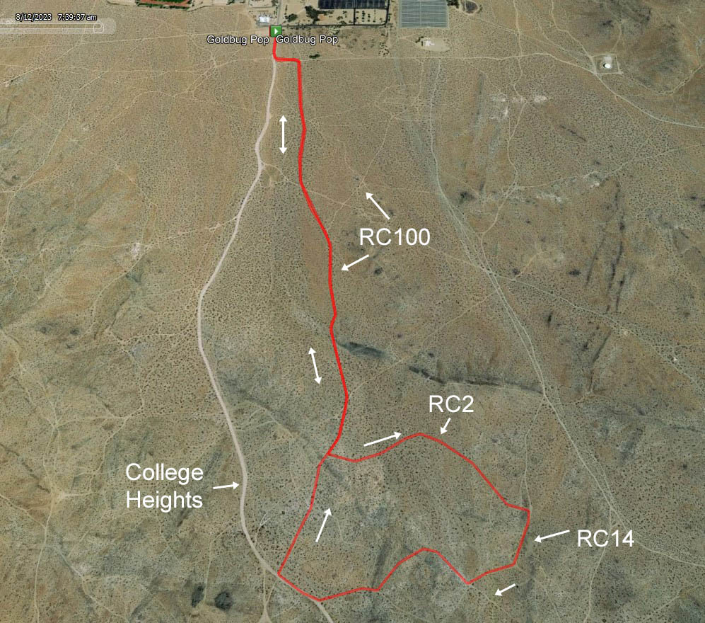
This course starts and finishes at the College trailhead. It is a 5K (3.1 mile) "lollipop" course (one that heads out, does a loop at the end, then backtracks to the finish) which goes out to the Goldbug mine and back. There is a little bit of history about this interesting mine on the 2021 Summer Challenge "Goldbug" course page. Connie enjoyed the 2021 course and wanted to take a different route through it with different views.
Course Description
Park at the College trailhead dirt parking lot. There will be ribbons marking the start/finish point. Head up (south) on the College Heights dirt road, then make a left at the college fence corner to head east. In about 200 feet (about mile .12 on the course), make a right turn onto an old, unmarked road to head south.
At about .47 miles, continue south on this same road as it crosses another road. At about .59 miles, merge onto RC100 to keep going south. At about .94 miles, keep left at the split/intersection to continue south on RC100.
At about 1.05 miles turn left onto RC2 to head east. At about 1.4 miles, turn right onto RC14 to head south up into the Goldbug mine area. The climb here is a bit more intense.
At about 1.5 miles, turn right on the road heading west (at the time of this writing, there is a large, old, blank BLM sign you will be heading toward). At almost 1.6 miles, make a right on the road heading west. A little further up, you will need to get up and over a rocky hill. On the other side of the hill at the bottom, make a right at the T to head west.
At just a bit over 1.8 miles, make a right onto the College Heights road to head briefly downhill/north (a few hundred feet). At 1.9-ish miles, make a right onto RC100 heading north/northwest. At around 2.1 miles you will complete the “loop” portion of the “lollipop” and reconnect with the path that brought you up.
All that’s left now is to backtrack to the finish. Continue straight down RC100 until about 2.56 miles, then veer left to exit onto that old unmarked road that will take you back to the college fence. Take a left at the fence, then continue around the fence corner to back to the finish. Nice job!

The green buttons will take you to a Course page on Garmin Connect, or a Route on Strava or MapMyRun. If you need a .gpx file, you will be able to download that from any of these route pages. You can review the route navigation instructions here.
Go to the Ridgecrest Running event page to post your results, photos, and to see what others are doing!