Billboard
Course Developer: Wesley Elmore
The start and finish of this course is at the billboard located at the south end of the Brady's ridge off of Highway 395. Coordinates of the billboard are 35.54598° N, 117.69481° W.

Course Description
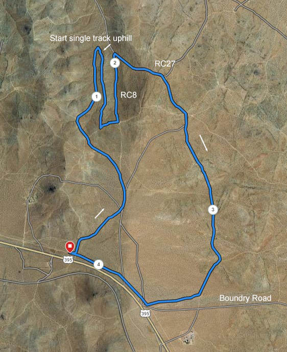
Most of the 4.1 mile course is on dirt roads, with one short section on single track. There is a brief overlap of 30 yards at the beginning and end of the course. Run the route clockwise. It will be marked with ribbons and signs.
To start, head east for 30 yards and turn left (north) at the first dirt road. At the base of the hill bear to the right. All mileage notations are approximate.
- 0.35 miles - merge with RC72 heading north.
- 0.44 miles - turn left onto RC 8.
- 0.5 miles - bear left, going uphill, heading northwest.
- 0.67 miles - bear to the right.
- 0.75 miles - at the top of the ridge go straight.
- 0.85 miles - bear right, to continue downhill.
- 1.25 miles - turn right onto a single track bike trail going uphill and heading south.
- 1.65 miles- at top of hill, turn left onto road, heading east.
- 1.73 miles -turn left onto dirt road (Downs extension/RC8) going downhill and heading north.
- 2.08 miles - turn right onto RC72, going uphill and heading southeast.
- 2.3 miles - bear to the right, continuing uphill.
- 2.5 miles - at the ridge top, bear to the right, going south.
- 2.6 miles - cross over the next road, continuing south (note: you are on the Classic Bike Course).
- 2.75 miles - FYI. You can get a glimpse of the billboard in the distance to your right front.
- 3.12 miles - Go right on older dirt road, continuing south.
- 3.25 miles - At red road marker bear to the right and merge with RC 79.
- 3.45 miles - Turn right.
- 3.70 miles- Turn right, heading northwest. Follow the road with telephone poles back to the billboard and the finish.

The green buttons will take you to a Course page on Garmin Connect, or a Route on Strava or MapMyRun. If you need a .gpx file, you will be able to download that from any of these route pages. You can review the route navigation instructions here.
Go to the Ridgecrest Running event page to post your results, photos, and to see what others are doing!