Rademacher Ridge Loop aka Build Trail & They will Come
Course Developer: Jessica Kormelink
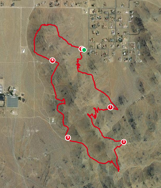
This loop circles the east Rademacher Ridge. It is 5 miles and is 90% trails with mild ascents and descents other than one solid hill climb. It starts at Gateway Trailhead, goes clockwise and is a fun loop on both newer and older trails. Please be aware that some of these trails are also used by mountain bikers, so be watchful of oncoming (or overtaking) cycling traffic.
Gateway Trailhead is located at the south end of Gateway Blvd., at the southwest corner of the Belle Vista development. To get there on pavement, turn left off College Heights Blvd on Kendall, go east to Richmond Road, turn south to Javis, and go back ot Gateway. Head south to the end of the road. There is some parking at the trailhead.
Course Description
Starting at the parking lot, take the trail leaving the southwest corner of the parking area, avoiding the wash that goes directly south. That trail divides soon: take the left branch to go slightly southwest, heading for some switchbacks. Stay left when another trail merges. Continue up to the saddle (with bench) and continue south. At about .6 miles take the left branch at the split in the trail, heading southeast. Follow this trail, crossing a dirt road in the wash, and continuing on the trail in the same direction. At .9 miles, take a sharp right (about 160 degrees from your original course) onto another trail. Take this trail all the way to the ridgeline.
At 1.5 miles, nearing the ridge, follow the marked path to the junction with another trail. Don't shortcut here. Turn sharply back to follow it in the southeast direction. This is not the ridgeline trail--instead it contours along the east side of the ridge. Take this trail to the mine, then take the dirt road going southeast until you hit 2 miles, at a junction. At this point, veer right (southwest) onto a trail that cuts over to another dirt road that goes straight up to the ridgeline.

At 2.1 miles, on the ridgeline, take the singletrack trail that heads down to the old water tank/mine ruins. At mine ruins take a strong right turn on the dirt road and follow it to 2.4 miles (just past the left downhill road) and take the trail that bypasses the steeper sections of the road. At the bottom, take the dirt road going downhill. At about 2.9 miles, watch for a trail heading off to the right. Follow this to 3.0 miles and turn right again onto a dirt road. Follow that to the wash.
At 3.1 miles, cross the wash and head up to a trail contouring along the hillside. Stay on this trail to the saddle just north of the Water Tank Trailhead. Crossing the saddle, stay high on singletrack--don't follow the steep road downhill. Continue on this trail to a junction at a small ravine. There, take the trail that heads down, taking the switchbacks down to an unmarked trailhead. Take the trail across from where you drop onto the road (higher trail).
Take this trail all the way to another old mine site (3.9 miles) located on the trail coming up from Sunland trailhead. Take the higher west trail. This trail does not go to the car park, but contours across the hill to a saddle. At this saddle take the upper trail that takes you north, around Sky Point. Soon after crossing the Sky Point summit trail, your trail splits for a short distance. The upper option will be more runnable. Continue around the mountain until you reach the yet another old mine ruin, from there, take the old road/trail back to the Gateway parking lot.
And you've completed the route!!!
The green buttons will take you to a Course page on Garmin Connect, or a Route on Strava or MapMyRun. If you need a .gpx file, you will be able to download that from any of these route pages. You can review the route navigation instructions here.
Go to the Ridgecrest Running event page to post your results, photos, and to see what others are doing!