Piece of Cake
Course Developer: Jenny McLaughlin
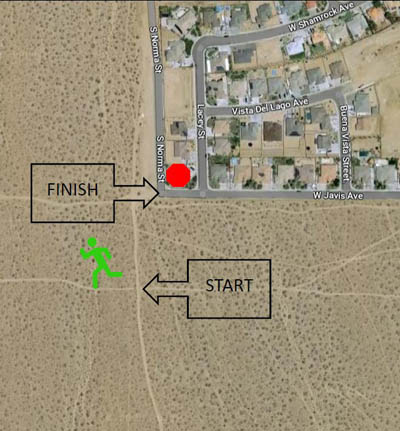
This is a point-to-point route, where the points are pretty close together. Because this course starts and finishes near civilization, it is highly likely that markings for the start and finish points will disappear quickly. So, there are no markings there. However, it is easy to find these points.
To get there by car: Head south on College Heights Blvd. Turn right onto Javis, which is last road in the housing area. Follow Javis to where it intersects Norma. Park somewhere legal. In the early morning, there is a nice bit of shade from the block walls along the east side of Norma.

The green buttons will take you to a Course page on Garmin Connect, or a Route on Strava or MapMyRun. If you need a .gpx file, you will be able to download that from any of these route pages. You can review the route navigation instructions here.
Course Description
Hike south (uphill) a scant tenth of a mile on this dirt road to where it intersects the Javis bike trail. There is a gate on your right at the entrance to the trail. This is the official start. Go!
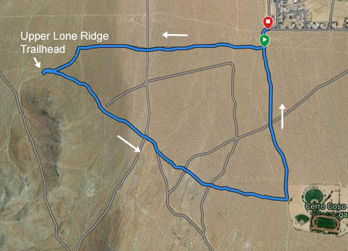
Head west (toward the Southern Sierra) on the Javis bike trail. You will cross over dirty Downs about half a mile in. At about 3/4ths of a mile from the start you reach another north-south dirt road with BLM number RC 71. Head to your left (south) for a few feet, then veer right at the fork onto RC 28 which heads towards the upper Lone Ridge trailhead.
At the upper Lone Ridge trailhead, loop around the parking lot by turning left into the 3rd or 4th entrance, whichever is not blocked by too many cars. In the middle of your loop, be sure to touch one of the signs at the trailhead—the low one is for short people, the kiosk for tall people.
After your loop, you will be heading east-ish, retracing your route on RC 28. But, not for long! At the fork, veer right onto RC 22, which skirts the base of Lone Ridge. At about 1.2 miles from the course start, a dirt road will merge into your road from the north. This is RC 71 again. Follow this road to the southeast, continuing along the base of Lone Ridge.
At about 1.3 miles from the start, the road forks. Veer left, away from Lone Ridge, onto RC 4. This will cross dirty Downs (RC 73) at about 1.5 miles. Continue on RC 4 until you reach a gate on your left at about 1.6 miles from the start. Veer left onto this nice trail.
This trail meanders towards the playing fields of Cerro Coso Community College. Enjoy!
This pleasant trail terminates at the dirt road that parallels the chain link fence around the playing fields. Head to your left. Charge downhill, lickety-split for about 3/4ths mile until both your feet have landed on the pavement at the intersection of Javis and Norma. Finished!
