Hilly Willy 2
Course Developer: Brian Hildreth
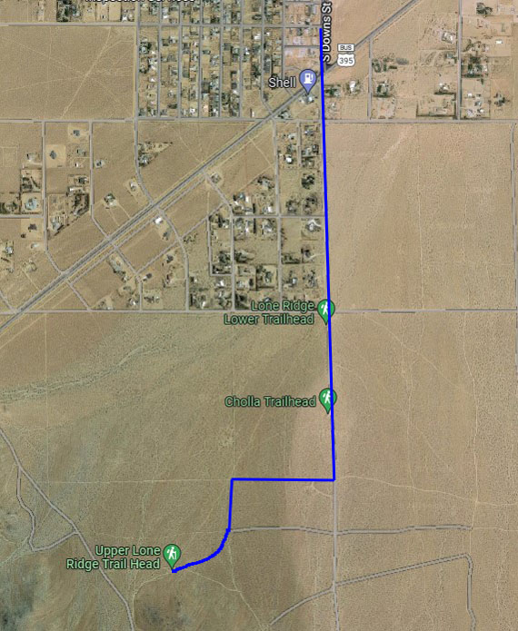
The start and finish for this run will be at the Upper Lone Ridge Trailhead. To get there, from town, take Downs south across China Lake Blvd. Drive south on Downs dirt road past the Lower Lone Ridge trailhead and parking area. Proceed south to RC69 and turn right. In about a quarter mile, turn left on RC71. Stay right at the fork and onto RC28. You will see the trailhead sign ahead. Parking here is limited, but there is some additional parking space along RC69, or back at the Cholla trailhead.

The green buttons will take you to a Course page on Garmin Connect, or a Route on Strava or MapMyRun. If you need a .gpx file, you will be able to download that from any of these route pages. You can review the route navigation instructions here.
Course Description
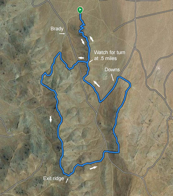
This course is a modified version of the Hilly Willy run that was hosted by Ty Hilton a few years ago. It's a challenging course, and Brian says it might be advisable to pre-run it before doing it for time! The distance is about 4.35, and the total elevation gain is about 1400 feet.
Head up Lone Ridge trail. You will pass a picnic table at the top at mile .3, stay on the main trail. At .5 turn right off of the ridgeline and go down the short steep rocky road. At the bottom of the hill, veer left toward a rock pile with a closed route marker. Proceed up the steep double track beyond the marker. At about .67 turn right and head down the double track on your right. At roughly .83 turn left and head up the wash.
At .97 follow the markers and veer left off of the wash and make an immediate right turn up a rocky road. When this road ends after about 100 yards, follow the single track to the right. You will see a mine on your right here. Follow this trail all the way up to the main ridgeline, crossing the single track trail known as "Brady Loop" or "Eureka". Turn left when you reach the ridgeline, which is RC63. Follow the ridge for .85 mile (mile 2.03).
Turn left down a semi-steep rocky road. At mile 2.15 head right down a short, not-so-well travelled canyon. Keep straight at the mountain bike trail crossing. Turn left on the dirt road when you reach a brown trail marker. After about 150 yards turn slightly right. You will now cross a main dirt road (Downs). Do not take the closed route up the hill in front of you, take the washed-out single track on the right. Head straight up the hill. Footing going up the hill is not so great so take your time up.
At the top of the hill, you should be at about mile 2.55, turn left. After about 75 feet the road will split. Stay right and follow the ridgeline north. At about mile 2.9 you start to descend off the ridgeline. Stay straight. Cross a wash at about 3 miles. At the next road, turn left onto RC70 and proceed downhill to the main dirt road (Downs). Turn left (uphill) on Downs.
After about .23 miles veer right near the RC71 marker. Pay attention to the course markings here. You should now be heading toward Lone Ridge once again. At the saddle (mile 3.71) turn right and head up the south part of Lone Ridge ridgeline. Follow Lone Ridge north all the way back to where you started.
