Brady Hills
This course explores a few hills near the Brady Trailhead. The course distance is about 4 miles. If you are unsure of the Brady Trailhead location, you can find it on Google Maps.
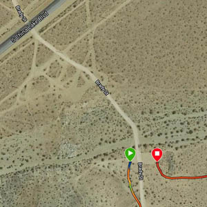
Turn off South China Lake Blvd. at the Brady Trailhead and pass the first parking areas. After crossing a wash, you will see a small parking area on each side of the road. The route leaves the west side parking area on a single track trail heading south. The finish will be on the opposite side, as shown by the red marker in the picture below.

The green buttons will take you to a Course page on Garmin Connect, or a Route on Strava or MapMyRun. If you need a .gpx file, you will be able to download that from any of these route pages. You can review the route navigation instructions here. The Strava route has some issues. If you plan to use the Strava app to follow this route, see the caveat in the detailed description. Otherwise, the Garmin Connect and MapMyRun routes look accurate.
Course Description
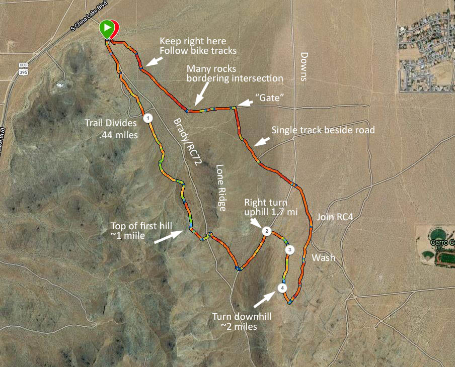
The course map below has been annotated to help relate the description to the map. The numbers on the map are my laps. They are identified in the description.

The first part of the course is on a trail used by mountain bike riders, usually traveling downhill. PLEASE KEEP YOUR EYES OPEN AND YIELD TO ANY RIDERS YOU ENCOUNTER. At .44 miles the trail branches (Lap 1). Take the right branch. You will be challenged by a few steep sections as the trail heads uphill. Shortly after reaching the 1 mile point, exit left on a road heading for the vicinity of the saddle at the upper end of Lone Ridge.
At the next junction (in about 0.1 mile) turn left toward the saddle. After crossing Brady, with the rock barriers on either side, turn right at the next opportunity. At the bottom, you will arrive at a 3-way junction. Turn downhill on the farthest-away branch. Enjoy this easy downhill stretch, for you are not finished yet!
Watch for a right turn (Lap 2), at about 1.7 miles from the start. At the top of this ridge (Lap 3), turn right and continue up a road along the ridge. The road steepens just before reaching a junction at about 2 miles (Lap 4). Turn left here to descend.
Now you will basically head downhill and back to the parking lot. Stay close to the ridge you were on, taking a left branch at a Y. As the road continues, it transitions to a wash until reaching a prominent road (RC4). Cross Downs near the nose of the ridge you just climbed and continue west. Just before the next intersection, turn right onto a single track that parallels the north-south road. When it leads you back to the road, stay right at this junction and continue north.
Just as you join a road coming from the Upper Lone Ridge Trailhead, you will see a wooden gate
on each side of the road, where a single-track crosses. Turn left onto the single track. Continue following this trail west until you reach an intersection that has a large number of rocks on the sides. Cross the intersection and immediately look for a bike trail heading diagonally to the right. Follow the bike tire tracks back to the east side of the parking lot.